Understanding air masses in aviation is essential for recognizing how large-scale weather patterns develop and change. An air mass is a large body of air with relatively uniform temperature and moisture characteristics, acquired over the region where it forms.
Why do some air masses bring clear skies while others produce low clouds, fog, showers, or turbulence? How can the same air mass change its characteristics as it moves over warmer or colder surfaces? And how can pilots use this information to anticipate weather conditions along a flight route?
This lesson explains the major types of air masses affecting North America and their source regions. We will examine how air masses form, how they change as they move, and how atmospheric stability influences clouds, precipitation, visibility, and turbulence. Finally, we will connect these concepts to practical flight planning and review common pilot exam questions.
Identify the major air mass types and explain how their origin, temperature, moisture, movement, and atmospheric stability influence aviation weather and flight-planning decisions.
Learn how air masses are classified, where they develop, and why their source regions determine their temperature and moisture characteristics.
Understand the difference between stable and unstable air and how stability influences cloud types, visibility, precipitation, and turbulence.
Discover how air masses change as they travel and how pilots can use these weather patterns to identify potential hazards before a flight.
Why can a moist air mass produce widespread low clouds and poor visibility in one situation, but cumulus clouds, turbulent air, and showers in another?
This lesson focuses on the characteristics and behavior of air masses. When air masses with different properties meet, they can form weather fronts. To understand cold fronts, warm fronts, stationary fronts, and occluded fronts, see our Aviation Weather Fronts Lesson .
What Are Air Masses?
Weather conditions can be very different across the United States on the same day. The northern Plains may experience cool, dry air while the Southwest is hot and dry and the southeastern states are warm and humid. These regional differences may result from the presence of several distinct air masses.
An air mass is an extensive body of air with relatively similar temperature and moisture characteristics across a large horizontal area. These properties are compared at approximately the same altitude.
Air masses are not small pockets of air. They can extend across hundreds or even thousands of miles, influencing weather over several states or an entire region.
The word relatively is important. Temperature and humidity do not have to be exactly identical at every location. An air mass is identified by its broad regional characteristics, even though local conditions may vary.
Three Basic Characteristics of an Air Mass
An air mass covers a broad region rather than a single airport or city. Its influence can extend across many states.
Air within the same mass generally has comparable temperature characteristics across the region when measured at similar altitudes.
The amount of water vapor in the air is also relatively consistent across the region. An air mass may be generally dry or moist.
Understanding Air Masses Across the United States
The illustration below shows how several air masses with different characteristics can influence different parts of the country at the same time.
The blue region represents a cool, dry air mass, while the orange region represents hot, dry air. The green region illustrates warm, moist air. Each mass occupies a large area with its own general temperature and moisture characteristics.
The shaded regions do not represent fixed boundaries. Air masses are constantly moving and changing, and their positions depend on the prevailing atmospheric conditions.
Two airports within the same air mass may experience different cloud cover, winds, or precipitation. Local terrain, daytime heating, and other weather processes can produce differences within the larger region. An air mass describes the broad characteristics of the atmosphere, not the exact weather at every location.
For pilots, recognizing these large-scale air patterns provides useful background information when interpreting aviation weather. Temperature and moisture help describe an air mass, but additional atmospheric conditions determine the weather a pilot will actually encounter.
Types of Air Masses: Classification and Examples
Meteorologists classify air masses according to two properties of their source regions: moisture and temperature. A short combination of letters identifies these characteristics and helps describe the kind of air affecting a particular region.
How to Read Air Mass Abbreviations
Moisture — Continental or Maritime
c — Continental: Air originating over large land areas. It is generally dry.
m — Maritime: Air originating over large bodies of water. It generally contains more moisture.
Temperature — Arctic, Polar or Tropical
A — Arctic: Extremely cold air from high Arctic regions.
P — Polar: Cool or cold air from higher latitudes.
T — Tropical: Warm or hot air from lower latitudes.
The lowercase letter indicates whether the air is continental or maritime. The uppercase letter identifies its temperature category. For example, mT means maritime tropical: warm, moist air associated with tropical waters.
Five Major Air Mass Types Affecting the United States
Four common air masses result from combining continental or maritime origins with polar or tropical temperatures. A fifth type, continental Arctic (cA), is especially important during outbreaks of extremely cold air.
| Air Mass | Temperature | Moisture | Typical Source Region |
|---|---|---|---|
|
cA
Continental Arctic
|
Extremely cold | Very dry | High Arctic regions, including northern Canada |
|
cP
Continental Polar
|
Cold | Dry | Interior Canada and other high-latitude land regions |
|
mP
Maritime Polar
|
Cool to cold | Moist | North Pacific and North Atlantic Oceans |
|
cT
Continental Tropical
|
Hot | Dry | Northern Mexico and the desert Southwest |
|
mT
Maritime Tropical
|
Warm | Moist | Gulf of Mexico, Caribbean Sea, and subtropical Atlantic |
Air Mass Examples in the United States
During winter, cold, dry air from the Canadian interior may move south across the northern and central United States. This is a typical example of a continental polar air mass.
Warm, humid air from the Gulf of Mexico may extend northward into Texas, Louisiana, and the Mississippi Valley. This is a typical example of a maritime tropical air mass.
An air mass classification describes the general temperature and moisture properties associated with its origin. It does not automatically tell a pilot whether the sky will be clear, cloudy, or rainy. Atmospheric stability and other weather processes must also be considered.

How Air Masses Form
Air masses develop when a large body of air remains over an extensive region long enough to acquire the temperature and moisture characteristics of the surface below. This process does not happen instantly. It requires a suitable geographic area and relatively persistent atmospheric conditions.
A source region is the large geographic area over which an air mass acquires its characteristic temperature and moisture properties. The surface must be sufficiently extensive and relatively uniform for these characteristics to develop across a broad area.
How an Air Mass Develops
Formation begins over an extensive region with relatively similar surface conditions. Large oceans, deserts, and snow-covered regions can provide these conditions.
The air must stay over the source region for several days or longer. Slow-moving weather patterns and relatively light winds allow sufficient time for this process.
The surface gradually warms or cools the air above it. Evaporation from water surfaces can also add moisture. Over time, the air develops the characteristics of its source region.
How the Surface Influences the Air
The Earth's surface plays a major role in determining the properties of a developing air mass. Heat is exchanged between the surface and the lower atmosphere, while evaporation can add water vapor to the air.
When air remains over a large, cold land surface, heat is transferred from the air toward the colder ground. The lower atmosphere cools. Snow- and ice-covered surfaces can help produce particularly cold air masses.
A warm ocean surface can transfer heat to the air above it. Evaporation also supplies water vapor. With sufficient time, the air can become relatively warm and moisture-rich.
These exchanges are strongest near the surface, but atmospheric mixing can distribute heat and moisture through a deeper layer of air. As a result, the developing mass acquires broadly similar properties across its source region.
Why Some Regions Are Better for Air Mass Formation
A good source region must provide both an extensive, relatively uniform surface and enough time for the air to acquire its characteristics. Frequent changes in weather systems can interrupt this process by moving the air away before it has fully developed those properties.
Broad, slow-moving high-pressure patterns can favor air mass formation by allowing air to remain over a source region for an extended period. However, high pressure alone does not determine the type of air mass. The underlying surface remains essential.
Much of the central and eastern United States experiences frequent changes in weather systems, making these areas less favorable for the prolonged development of new air masses. Many of the air masses affecting U.S. flights therefore originate in broader regions to the north, over surrounding oceans, or in extensive desert areas.
Once an air mass begins moving away from its source region, it may encounter surfaces with different temperatures and moisture conditions. These encounters can gradually change its original characteristics.
How Air Masses Change as They Move
An air mass does not necessarily keep the same temperature and moisture characteristics throughout its journey. Once it leaves its source region, it may travel over land or water that is warmer, colder, wetter, or drier than the surface where it formed.
These new surroundings can gradually change the air mass, particularly in its lower layers. This process explains why an air mass arriving in one part of the United States may have different characteristics from those it had when it first began moving.
Air mass modification is the change in an air mass's temperature, moisture, or other properties as it moves away from its source region and interacts with different surfaces and surrounding air.
Advection and Convection: Two Ways Air Moves
Air moves through the atmosphere in different directions. Two important processes are advection and convection. Both transport heat and moisture, but they describe different types of atmospheric movement.
Advection is the horizontal transport of air or atmospheric properties, such as temperature and moisture, by the wind.
For example, southerly winds can carry warm, moist air from the Gulf of Mexico into the central United States. This is an example of warm, moist air advection.
When moist air is transported over a colder surface, it may cool to its dew point and produce advection fog.
In meteorology, convection refers to vertical air movement that transports heat and moisture, particularly through rising and descending currents in an unstable atmosphere.
For example, strong sunshine can heat the ground and warm the air immediately above it. If this air becomes buoyant, it rises and forms a thermal updraft.
Convection may produce turbulence and, when sufficient moisture is present, cumulus clouds, showers, or thunderstorms.
Imagine warm, moist air moving northward from the Gulf of Mexico into the central United States.
The horizontal transport of this air is advection.
If strong sunshine subsequently heats the ground and makes the lower atmosphere unstable, rising air currents may develop. This vertical circulation is convection.
The result depends on the moisture and stability of the atmosphere. The same transported air mass may experience weak convection, strong thermals, or deeper cloud development.
Advection helps explain how an air mass and its temperature and moisture properties reach a new region. Convection helps explain how heat and moisture can be transported vertically within the atmosphere. These processes can occur simultaneously and influence the weather that develops.
How Surface Temperature Changes a Moving Air Mass
The temperature difference between the moving air and the surface beneath it determines the direction of heat transfer.
When cold air moves over warmer land or water, heat passes from the surface into the lower atmosphere. The air near the ground warms first. This heating can encourage vertical air movement and mixing.
When warm air travels over a colder surface, it loses heat to the ground or water below. Cooling begins near the surface and can reduce vertical mixing. If moist air cools sufficiently, its relative humidity rises and condensation may occur.
Heat and moisture enter the air as it crosses relatively warm, unfrozen lake water.
Heat leaves the lower air as it travels over a colder land surface.
How Moisture Changes During Movement
Temperature is only part of the process. The moisture content of an air mass can also change, depending on the surface beneath it and the weather that develops within it.
When air passes over a body of water, evaporation can add water vapor to its lower layers. This is especially important when cold, relatively dry air crosses warmer water.
Water vapor can be removed when it condenses into cloud droplets or ice crystals. If precipitation falls out of the air mass, its overall moisture content may decrease.
An air mass can also mix with surrounding air that has different temperature and moisture characteristics. These processes mean that the changes are not always limited to the air touching the surface.
A U.S. Example: Cold Canadian Air Over the Great Lakes
During late fall and winter, cold, relatively dry air from Canada sometimes crosses the Great Lakes while the lake water remains unfrozen and warmer than the air above it.
As the air travels over the water, it gains heat and moisture from below. This can promote rising air and cloud development. Under suitable conditions, narrow bands of lake-effect snow form downwind of the lakes.
The important point is that the air arriving on the downwind shore is no longer identical to the air that first moved over the lake.
What Determines How Much an Air Mass Changes?
An air mass may undergo considerable modification or only a small change. Three factors are especially important:
A larger temperature contrast between the air and the underlying surface can produce stronger heat exchange.
The longer an air mass remains over a different surface, the more opportunity it has to exchange heat and moisture.
Land, water, snow, and vegetation affect heat and moisture exchange differently. Atmospheric mixing influences how far these changes extend upward.
Air mass modification is generally gradual. A moving air mass does not automatically become a completely different type simply because it crosses a coastline or passes over a lake. Its properties evolve as it interacts with new surroundings.
One particularly important result of this modification is a change in the air mass's tendency to resist or encourage vertical motion. This leads to the distinction between stable and unstable air masses.
Stable vs. Unstable Air Masses
Two air masses can have similar temperatures and moisture levels but behave differently when air is lifted. This difference depends on atmospheric stability.
Stability determines whether rising air tends to return toward its original level or can continue moving upward. It is an important factor in understanding convection and the development of aviation weather.
Atmospheric stability describes the tendency of air to resist or support vertical movement.
Stable air resists continued rising. Unstable air can continue rising after an initial lift.
What Happens When Air Is Lifted?
Imagine a small amount of air being pushed upward by terrain or another lifting force.
As it rises, the surrounding atmospheric pressure decreases. The air expands and cools.
Whether it continues rising depends on its temperature compared with the surrounding air at the same altitude.
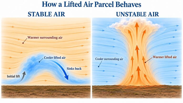
Lifted Air Tends to Sink Back
In stable conditions, the lifted air becomes colder than the surrounding air at the same altitude.
It is therefore denser than the air around it. If the lifting force stops, it tends to sink back toward its original level.
Result: Continued vertical movement is resisted.
Lifted Air Can Continue Rising
In unstable conditions, the lifted air remains warmer than the surrounding air at the same altitude.
Because it is less dense than the air around it, it experiences an upward buoyancy force and can continue rising after the initial lift.
Result: Continued vertical movement is supported.
What Makes an Air Mass Stable or Unstable?
Stability depends largely on how air temperature changes with altitude. The temperature of the lower atmosphere and the air above it can create conditions that favor or resist rising air.
The two diagrams below show common examples.
Example 1 — Stable Conditions
What happens? Cooler air lies near the ground, with a warmer layer above it. This temperature inversion strongly resists upward movement and favors stable conditions.
Example 2 — Unstable Conditions
What happens? Strong surface heating warms the lowest air layers. If temperature decreases sufficiently rapidly with altitude, lifted air can remain warmer than its surroundings and continue rising.
The diagrams show typical situations, not fixed rules. A stable layer can occur at one altitude while an unstable layer exists at another.
How Does Moisture Affect Stability?
Moisture also influences the behavior of rising air.
As unsaturated air rises, it expands and cools. When the air becomes saturated and condensation begins, latent heat is released. This reduces the rate at which the rising air cools.
Under suitable atmospheric conditions, the reduced cooling allows the rising air to remain warmer than its surroundings and continue upward.
Key Point
Stable air: A lifted parcel becomes cooler and denser than its surroundings, so it tends to return toward its original level.
Unstable air: A lifted parcel remains warmer and less dense than its surroundings, so it can continue rising.
Remember: Stability depends on the vertical temperature structure of the atmosphere, not simply on whether an air mass is warm or cold.
In the next section, we will see how these characteristics affect the weather conditions pilots may encounter during flight.
How Air Masses Affect Aviation Weather
An air mass influences more than the temperature and humidity reported at the surface. Its characteristics also help determine the clouds, visibility, precipitation, and other weather conditions that pilots may encounter.
As we have seen, advection transports air horizontally, while convection involves vertical movement. Atmospheric stability affects how readily that vertical movement can continue. Together with moisture, lifting mechanisms, and terrain, these processes help shape the resulting weather.
An air mass provides clues about the weather, but does not determine the complete forecast.
Pilots must consider the amount of moisture available, the stability of the atmosphere, and any lifting or cooling that may produce clouds and precipitation.
Clouds, Ceilings, and Visibility
Cloud cover and visibility are among the most important weather conditions for flight operations. Moisture and stability strongly influence the type and vertical extent of clouds that develop.
Low Clouds and Reduced Visibility
Moist, stable air often favors broad layers of stratus clouds, especially when the air is cooled sufficiently to reach saturation.
Low cloud bases, fog, and mist can reduce the ceiling or surface visibility, sometimes over a large area.
For example, advection of warm, moist air over a colder surface can produce advection fog, restricting visibility near airports.
Cumulus and Vertically Developing Clouds
Moist, unstable air supports the development of cumulus clouds when sufficient lifting and condensation occur.
With stronger vertical development, clouds may grow into towering cumulus or cumulonimbus.
Cloud bases and visibility can vary considerably across an area, particularly near developing showers.
What Pilots Need to Distinguish
Ceiling is the height above ground of the lowest broken or overcast cloud layer, or the reported vertical visibility into an obscuration.
Visibility describes how far a pilot can see horizontally through the atmosphere.
A low ceiling and poor visibility often occur together, but they are not the same measurement. Either can restrict flight operations.
Precipitation and Thunderstorms
When moist air is lifted and cools enough for cloud droplets or ice crystals to grow, precipitation may develop. The atmosphere's stability helps influence whether that precipitation is widespread or concentrated in developing convective clouds.
Persistent Rain, Snow, or Drizzle
Widespread, relatively gentle lifting of moist air often produces layered clouds and stratiform precipitation.
Rain or snow may cover a broad area and continue for an extended period. Drizzle may also occur beneath low stratus clouds.
Pilot concern: Persistent low ceilings, poor visibility, and reduced terrain clearance in mountainous areas.
Showers and Thunderstorms
When sufficient moisture, instability, and lifting are present, growing convective clouds can produce localized showers or thunderstorms.
Conditions may change rapidly near these clouds, with intense precipitation, strong updrafts and downdrafts, and potentially severe turbulence.
Pilot concern: Rapidly changing visibility, dangerous convective activity, and weather that can extend beyond the visible rain shaft.
Important Distinction
An unstable air mass does not automatically produce thunderstorms. Adequate moisture and a mechanism capable of initiating or supporting cloud development are also needed.
Similarly, stable air can produce significant precipitation when large-scale lifting is present.
Aircraft Icing
Air mass characteristics can also help identify environments where aircraft icing may occur.
In-flight icing is especially associated with clouds or precipitation containing supercooled liquid water droplets. These droplets remain liquid below freezing and can freeze when they strike an aircraft.
Icing in Widespread Cloud Layers
Moist air may produce extensive cloud layers containing supercooled liquid water.
Depending on cloud temperature and liquid water content, an aircraft passing through these layers may encounter icing over a considerable distance.
Icing in Strong Vertical Development
Developing cumulus and cumulonimbus clouds can contain substantial amounts of supercooled liquid water within appropriate temperature ranges.
Convective clouds may combine icing with turbulence, strong vertical air currents, and heavy precipitation.
Important — Cold Air Does Not Always Mean Icing
Freezing temperatures alone do not guarantee airframe icing. The presence and type of moisture are essential considerations.
Freezing rain or freezing drizzle can also create particularly dangerous icing conditions, even without thunderstorms.
Pilots must assess forecast icing conditions, freezing levels, cloud layers, and aircraft limitations. Air mass classification alone is not sufficient.
Turbulence and Wind Shear
Vertical air movement, wind differences, and terrain can all contribute to turbulent conditions. Air mass stability provides useful clues, but it is not the only factor.
Strong updrafts and downdrafts in unstable air can produce turbulence, especially around developing cumulus and thunderstorms.
Changes in wind speed or direction over a short distance can create wind shear. It may occur near fronts, temperature inversions, or other atmospheric boundaries, including within otherwise stable air.
Strong winds interacting with mountains can produce mechanical turbulence, mountain waves, and rotors. Some of these hazards can occur in stable atmospheric conditions.
Do Not Assume Stable Air Is Always Smooth
Stable conditions generally suppress buoyant vertical motion, but they do not eliminate turbulence. Wind shear, strong winds over terrain, and mountain-wave activity can still create hazardous flight conditions.
Aviation Weather Examples Across the United States
The following examples show how the characteristics of different air masses can influence aviation weather in familiar U.S. regions.
Warm, Moist Air from the Gulf of Mexico
Maritime tropical air frequently brings abundant moisture into the Gulf Coast states and the southeastern United States.
When this air moves over a colder surface, low stratus clouds or advection fog may form, reducing visibility and ceilings.
At other times, daytime heating and suitable instability can support convective showers and thunderstorms.
Aviation significance: The same general air mass can be associated with very different flying conditions depending on surface temperatures and atmospheric stability.
Cool, Moist Air Moving Inland from the Pacific
Maritime polar air moving toward Washington and Oregon often brings extensive moisture, cloud cover, and precipitation.
When moist airflow encounters the Cascade Range and other elevated terrain, low ceilings and mountain obscuration may become important aviation concerns.
Aviation significance: Cloud bases and visibility may vary considerably along a route, particularly where terrain forces moist air upward.
Key Point
Air masses influence cloud types, ceilings, visibility, precipitation, icing, and turbulence.
Their effects depend on moisture, stability, lifting mechanisms, temperature, and terrain.
For pilots, an air mass classification is a starting clue—not a complete weather forecast. Actual and forecast conditions must be evaluated using appropriate aviation weather information.
The next section explains how to combine air mass information with aviation weather reports, forecasts, and charts when preparing for a flight.
Using Air Mass Information for Flight Planning
Knowing which air mass is affecting an area can help a pilot anticipate general weather trends. However, the next step is to determine what conditions actually exist and what is expected along the planned flight.
A useful preflight weather assessment moves from the overall weather pattern to the specific conditions at departure, along the route, and at the destination.
Use air mass information to ask better weather questions, not to make a flight decision by itself.
The location and movement of an air mass provide context. Current observations, forecasts, advisories, and pilot reports provide the information needed to evaluate a particular flight.
1. Identify the Air Mass Along Your Route
Begin with the large-scale weather situation. A surface analysis chart can show the position of high- and low-pressure systems, frontal boundaries, and the general movement of weather systems across the United States.
Use surface analysis and forecast charts to answer three questions:
Where Is the Air Mass?
Identify the general air mass affecting your departure area and the regions you intend to cross.
Where Is It Moving?
Look at the expected movement of pressure systems and fronts during the planned flight period.
Will Conditions Change?
Determine whether the route may cross into a different air mass or experience a significant change in the weather pattern.
This gives you the general picture before examining individual airport forecasts.
2. Check Current Conditions and Forecast Weather
Next, compare the broad weather pattern with actual aviation weather information.
For flights in the United States, the Aviation Weather Center provides access to the principal observations, forecasts, and advisories used during preflight weather preparation.
METARs and TAFs
Use METARs to examine current reported conditions, including visibility, clouds, wind, temperature, and significant weather.
Use TAFs to evaluate forecast conditions at covered airports during your expected departure and arrival periods.
Graphical Forecasts for Aviation
Use the GFA to examine forecast weather across the planned route, including ceilings, visibility, clouds, winds, precipitation, turbulence, and icing where available.
Compare the forecast conditions with the flight's planned route, altitude, and timing.
G-AIRMETs and SIGMETs
Review applicable G-AIRMETs, SIGMETs, and other relevant aviation weather advisories.
Determine whether any identified hazards affect the planned route or operating altitude.
PIREP, Radar, and Satellite Information
PIREPs provide reports of conditions actually encountered by other pilots.
Radar and satellite imagery help show the location and development of precipitation and cloud systems.
Always check the observation time and limitations of each product.
Compare Different Sources
A forecast is more useful when it is compared with recent observations. If actual weather is developing differently from the forecast, reassess the plan using the latest available information.
3. Evaluate the Entire Flight, Not Just the Airports
Good weather at departure does not guarantee good conditions throughout the flight.
Evaluate the planned route as a whole, including the flight altitude, surrounding terrain, alternative airports, and the time at which each area will be reached.
Departure
Assess observed and forecast conditions near the departure airport, including the expected weather at takeoff time.
En Route
Examine conditions along the route and at planned altitudes, including clouds, visibility, winds, terrain, and applicable weather hazards.
Destination
Check conditions near the expected arrival time and evaluate suitable alternatives if the weather changes.
Consider how the conditions may develop during the flight, not only how they look at the time you check the weather. A forecast improvement or deterioration may change the suitability of a departure time or route.
4. Turn the Weather Information into a Decision
After reviewing the weather, compare the expected conditions with your qualifications, experience, personal minimums, aircraft limitations, and available alternatives.
The result should be a clear decision supported by the overall weather picture.
Proceed
Conditions support the planned flight within applicable regulations, aircraft limitations, and the pilot's personal minimums. Continue monitoring for changes.
Change the Plan
A different departure time, route, destination, or altitude may reduce risk, provided the revised plan is evaluated with updated weather information.
Delay or Cancel
If conditions exceed acceptable limits or important uncertainties remain unresolved, delaying or canceling the flight may be the safest decision.
Practical Example: A VFR Flight in the Central United States
Consider a student pilot planning a daytime VFR cross-country flight from Des Moines, Iowa, to Omaha, Nebraska.
The following is a hypothetical training example, not a current weather forecast.
Des Moines → Omaha
A surface analysis chart shows that a cold front has moved through the region. Colder continental air is spreading across Iowa and Nebraska.
Recent METARs show improving cloud conditions along much of the proposed route.
The destination TAF forecasts strong, gusty northwest winds near the planned arrival time. After considering the available runway orientations, the pilot calculates a possible crosswind component above their personal limit.
Even though the general air mass suggests improving cloud conditions, the wind forecast makes the original plan unsuitable for this pilot. The pilot should reassess the options, such as delaying the flight or selecting a suitable alternative, using an updated briefing.
This example demonstrates why air mass information must be combined with operational weather details. A generally favorable weather trend does not mean every condition along the route is acceptable.
U.S. Aviation Weather Resources
Aviation Weather Center — Official aviation observations, forecasts, graphical weather information, and advisories.
Flight Service — 1800WXBRIEF — Preflight briefing services and aviation weather planning resources.
Key Point
Air mass information helps explain the general weather pattern, but flight decisions require current and forecast aviation weather information.
Evaluate the complete route, expected flight times, operating altitudes, available alternatives, and personal and aircraft limitations.
Continue reassessing weather as conditions change. This focused air mass assessment forms part of a complete preflight briefing, which must also address other applicable aeronautical information.
Key Takeaways
The following points summarize the essential concepts every student pilot should remember about air masses and their influence on aviation weather.
Air Mass Characteristics
An air mass is a large body of air with relatively uniform temperature and moisture characteristics.
Classification
Air masses are classified by their moisture characteristics and source-region temperatures, using designations such as cP, mP, cT, and mT.
Formation and Modification
Air masses acquire their characteristics over source regions, then gradually change as they move over different surfaces.
Air Movement
Advection transports air horizontally, while convection involves vertical transport of heat and moisture.
Atmospheric Stability
Stable air resists continued vertical movement. Unstable air can support continued rising when lifted air remains warmer than its surroundings.
Aviation Weather
Air mass properties help influence clouds, ceilings, visibility, precipitation, icing, and turbulence.
Flight Planning
Use air mass information to understand the general weather pattern, then verify conditions with current observations, forecasts, and applicable aviation weather advisories.
Knowing the air mass helps you understand what weather may develop. Knowing the actual and forecast conditions helps you decide whether the flight is suitable.
Always evaluate the complete route, planned altitude, and expected flight time rather than relying on air mass classification alone.
Typical Exam Questions
Test your understanding of air mass classification, source regions, air mass modification, atmospheric stability, convection, aviation weather hazards, and flight planning. Choose one answer for each question. You will receive an explanation after every answer.