What Is a Weather Front?
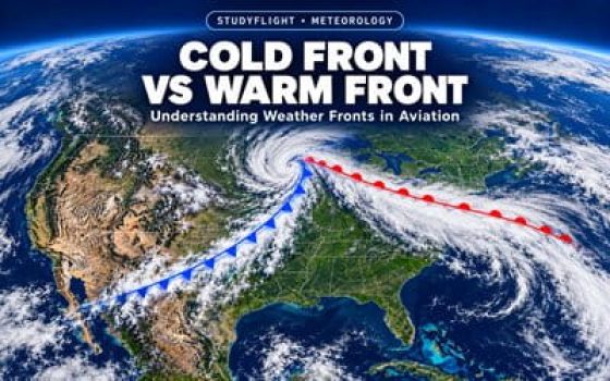
A weather front is a transition zone between two air masses with different physical characteristics, especially temperature and density. These air masses may also differ in moisture content.
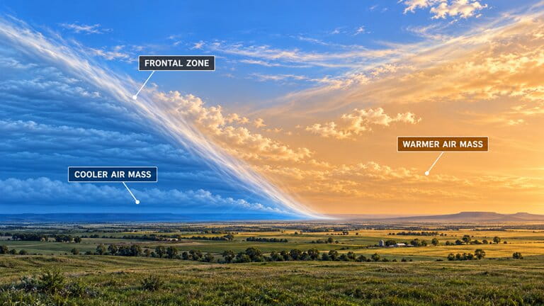
When two contrasting air masses meet, they do not usually mix immediately. Instead, a boundary develops between them. This boundary is called a frontal zone.
Understanding the Illustration
- Cooler air mass (blue): The blue region represents relatively cool, dense air. Cooler air generally tends to remain below warmer, less-dense air.
- Warmer air mass (orange): The orange region represents warmer, less-dense air. Near a frontal boundary, warmer air can extend upward above the cooler air.
- Frontal zone (inclined boundary): The sloping transition between the two air masses shows that a front is not simply a vertical dividing line. The frontal surface generally slopes over the cooler air. Its slope and structure vary with the type of front and the atmospheric conditions.
The illustration shows the general structure of a front, not its direction of movement. A front may advance, retreat, or remain nearly stationary. The way the air masses move relative to each other helps determine which type of front develops.
Why Do Weather Fronts Matter?
A front marks a region where atmospheric conditions can change over a relatively short distance. For pilots, three features are especially important:
Temperature and Moisture
The air on opposite sides of a front may have noticeably different temperatures and humidity levels.
Wind and Pressure
Wind direction, wind speed, and atmospheric pressure patterns can change across a frontal zone.
Clouds and Precipitation
If sufficient moisture and lifting are present, clouds and precipitation may develop near or around the front.
Cold Front: Formation, Clouds and Weather
A cold front forms when an advancing mass of colder air moves into an area occupied by warmer air.
Because the colder air is denser, it pushes beneath the warmer air and forces it upward. This lifting can produce clouds, precipitation, and sometimes thunderstorms.
How a Cold Front Forms
The leading edge of the advancing cold air acts like a wedge. As it moves forward, it lifts the warmer air above it.
The key process: Cold air advances beneath warmer air → the warmer air rises → the rising air cools → clouds may form if the air contains enough moisture.

Reading the diagram: The blue arrows show the colder air advancing near the ground. The red arrows show warmer air being lifted along the frontal boundary. In this example, rising moist air produces a cumulonimbus cloud and heavy precipitation. This illustrates an active cold front, not the conditions produced by every cold front.
Clouds and Precipitation Associated with Cold Fronts
The clouds produced by a cold front depend mainly on the moisture and stability of the warmer air being lifted.
When the air is moist and unstable, rapid upward movement can produce:
- Cumulus (Cu): Clouds with vertical development that may indicate growing convection.
- Towering cumulus (TCU): Strongly developing clouds that may grow into thunderstorms.
- Cumulonimbus (Cb): Thunderstorm clouds capable of producing heavy rain, lightning, hail, strong turbulence, and dangerous wind changes.
Not every cold front produces thunderstorms. If the warm air is relatively dry or stable, cloud development may be limited. Some cold fronts produce mainly layered clouds and widespread precipitation, while others pass with little precipitation.

Reading the diagram: The frontal boundary is located where the colder air advances beneath the warmer air. Strong lifting near this boundary produces the cumulonimbus (Cb) cloud and precipitation shown in the illustration. The upper cloud shield extends away from the main storm area, with high-level clouds such as cirrus (Ci) and cirrostratus (Cs).
This is one possible arrangement of clouds. There is no fixed cloud sequence that occurs with every cold front. Cloud coverage and precipitation can extend ahead of the surface front, along it, or behind it, depending on the weather system.
Weather Before, During, and After a Cold Front
A cold front often produces noticeable changes in a relatively short period. The following pattern is common, but actual conditions vary.
Before the Front
Warmer conditions are common. Clouds may increase, winds may strengthen, and atmospheric pressure often falls as the front approaches.
During Passage
Winds often shift and become gusty. Temperature may drop sharply. Showers or thunderstorms can produce reduced visibility and turbulence.
After the Front
Cooler air usually follows, and pressure often rises. Visibility may improve, but clouds, gusty winds, and showers can continue behind the front.
What Makes a Cold Front Important to Pilots?
The most significant aviation hazards are usually associated with strong lifting, rapidly changing winds, and convective weather.
- Thunderstorms: Moist, unstable air may produce cumulonimbus clouds with intense precipitation, lightning, hail, and severe turbulence.
- Wind shifts and gusts: Changing wind direction and speed can create challenging conditions, particularly during takeoff and landing.
- Low visibility and ceilings: Rain, snow, and associated cloud cover may reduce visibility and create IFR conditions.
- Icing: In suitable temperature and moisture conditions, flight through clouds or precipitation may expose an aircraft to structural icing.
Pilot reminder: Do not assume that weather improves immediately after a cold front passes. The colder air behind the front may remain unstable, allowing additional showers, turbulence, or gusty winds to develop.

Warm Front: Formation, Clouds and Weather
A warm front forms when a cold air mass retreats and warmer air takes its place. It is the opposite of a cold front, where cold air advances and replaces warm air.
As the cold air retreats, the advancing warm air slides gently up and over it. As the warm air rises, it cools, allowing clouds to form when sufficient moisture is present.
This gradual lifting can create an extensive area of clouds and precipitation well ahead of the warm front's position at the surface.
How a Warm Front Forms
A warm front generally has a relatively gentle slope. As the warm air advances, it moves upward along this inclined boundary.
If the rising air contains sufficient moisture, cooling causes water vapor to condense into clouds. Because the lifting may extend over a large area, the resulting cloud cover can be widespread.
The key process: Warm air advances over cooler air → rises along a gentle slope → cools as it rises → develops extensive clouds and, when conditions permit, precipitation.

Understanding the illustration: The warm air is shown advancing up a gently sloping boundary above the cooler air. The clouds become thicker where lifting and condensation are more developed. Precipitation can reach the ground on the cool side of the surface front, before the warmer air arrives at that location.
Clouds and Precipitation Ahead of a Warm Front
One of the most recognizable features of a typical active warm front is the progression from high, thin clouds to thicker and lower cloud layers.
For a pilot approaching the front from the cooler side, the following sequence is often associated with moist, stable air:
- Cirrus (Ci): Thin, high-altitude clouds may be the first visible indication of an approaching frontal system.
- Cirrostratus (Cs): A thin, widespread cloud layer may cover more of the sky. It can sometimes produce a halo around the Sun or Moon.
- Altostratus (As): A thicker, middle-level cloud layer develops. The sky becomes increasingly overcast, and the Sun may appear dim or disappear behind the clouds.
- Nimbostratus (Ns): Thick clouds may produce widespread, relatively steady rain or snow. Low stratus, mist, or fog may also develop near the surface.
This is a typical example, not a mandatory cloud sequence. Some warm fronts have little precipitation, while others produce embedded convective clouds or thunderstorms when the atmosphere is unstable.

Reading the diagram: The surface warm front is located toward the left. The cooler air extends to the right, underneath the rising warm air. Moving from right to left across the illustration, the cloud layers generally become lower and thicker. The diagram also shows how precipitation may fall as snow in colder air or rain where temperatures allow. Fog can develop near the ground.
The distance shown in the diagram is illustrative. Actual cloud and precipitation areas depend on moisture, atmospheric stability, and the structure of the weather system.
Weather Before, During, and After a Warm Front
At a fixed location, weather often changes progressively as a warm front approaches and passes.
Before the Front
Cool conditions usually persist at the surface. Cloud layers may thicken and lower, precipitation may begin, and atmospheric pressure often falls.
During Passage
Low clouds, drizzle, mist, or poor visibility may occur. Temperature and dew point generally rise as warmer air reaches the surface.
After the Front
Warmer air becomes established near the ground. Wind direction may change, and precipitation may decrease, although low clouds can persist.
In a typical Northern Hemisphere midlatitude weather system, surface winds may shift from easterly or southeasterly ahead of a warm front toward southerly or southwesterly after its passage. However, the exact wind shift depends on the pressure pattern and the front's orientation.
Why Warm Fronts Matter to Pilots
Warm fronts can create difficult flying conditions even when no thunderstorms are present. Their effects may cover a broad geographic area and last for an extended period.
- Low ceilings: Extensive stratus and nimbostratus layers may reduce cloud bases below VFR operating requirements.
- Poor visibility: Rain, snow, mist, and fog can reduce forward visibility and create widespread IFR conditions.
- Aircraft icing: Supercooled liquid water in clouds can create icing conditions. In winter, freezing rain may also occur when precipitation falls through a warm layer aloft and then enters subfreezing air near the surface.
- Weather far ahead of the front: A pilot may encounter low ceilings or precipitation long before reaching the frontal line shown on a surface weather chart.
Pilot reminder: The surface location of a warm front does not show the full extent of its weather. Clouds, reduced visibility, and precipitation may already affect airports and flight routes far ahead of the front.
Stationary Front: Characteristics and Weather
A stationary front forms when a boundary between two air masses remains in approximately the same position because neither air mass is advancing enough to replace the other.
Unlike a cold front or a warm front, a stationary front shows little or no movement across the ground. It may remain over the same region for several hours or even days.
Remember: A stationary front is a frontal boundary that moves very little. The air on either side can still be moving, and significant weather can still develop.
Why Does a Stationary Front Remain in Place?
A stationary front develops when the movement of the surrounding air masses does not produce a clear advance of either the warm or the cold air at the surface.
Winds may flow along the boundary or toward it without causing the front itself to move significantly.
Even though the surface boundary remains nearly stationary, warmer air may still rise over cooler air. If enough moisture is present, this lifting can produce clouds and precipitation.

Understanding the illustration:
- Cool air (blue): The cooler air mass occupies one side of the boundary.
- Warm air (red): The warmer air mass is located on the opposite side.
- Opposing arrows: These represent air movement toward the frontal zone. They do not mean that the frontal boundary itself is moving across the ground.
- Clouds and precipitation: The illustration shows one possible active stationary front, where rising moist air produces significant cloud development and precipitation.
A stationary front does not always produce towering clouds or heavy precipitation. Its weather depends on moisture, stability, and the amount of lifting along the boundary.
What Weather Can a Stationary Front Produce?
Stationary fronts can produce very different weather conditions. Three situations are particularly useful for student pilots to understand.
Dry Conditions
If little moisture is available, cloud development and precipitation may be limited, even though the frontal boundary remains present.
Moist, Stable Air
Layered clouds, low ceilings, fog, and prolonged rain or snow may affect the same region for an extended period.
Moist, Unstable Air
Showers and thunderstorms may repeatedly develop or move along the front, sometimes producing heavy rainfall over the same locations.
Why Can Bad Weather Last So Long?
The main difference between a stationary front and a moving front is the limited movement of the frontal boundary.
When clouds and precipitation continue to develop near a stationary front, the same airports and flight routes may experience poor conditions for a prolonged period.
Example: A stationary front remains over the central United States. Moist air continues to flow toward the boundary. If the atmosphere supports repeated cloud and precipitation development, nearby airports may experience low ceilings, rain, or thunderstorms for many hours.
Under favorable conditions, thunderstorms may move repeatedly over the same area. This is sometimes called training, and it can lead to exceptionally heavy accumulated rainfall.
However, the front itself does not have to remain perfectly motionless. Small shifts in its position can change which locations receive rain, snow, or thunderstorms.
Can a Stationary Front Start Moving Again?
Yes. A stationary front can begin moving when the atmospheric conditions change.
- If the cold air begins advancing and replaces the warmer air, the boundary becomes a cold front.
- If the cold air retreats and warmer air advances to replace it, the boundary becomes a warm front.
Low-pressure disturbances may also develop along a stationary front, changing its shape, movement, and associated weather.
What Does a Stationary Front Mean for Pilots?
For aviation, the most important characteristic of a stationary front is not simply its position. It is the possibility that unfavorable weather may persist over the same area.
Depending on the conditions, pilots may encounter prolonged low ceilings, reduced visibility, precipitation, or repeated convective activity.
Pilot reminder: A stationary front does not mean stationary weather conditions. The boundary may remain in place while clouds, precipitation, and thunderstorms continue to develop and change.

Occluded Front: Cold and Warm Occlusions
An occluded front forms when a cold front catches up with a warm front.
As the two fronts come together, the WARM AIR between them is forced upward, away from the Earth's surface. COLD AIR and COOL AIR then meet near the ground.
The key idea: During an occlusion, the WARM AIR is lifted above the surface. The difference between a cold occlusion and a warm occlusion depends on whether COLD AIR or COOL AIR is advancing near the ground.
How an Occluded Front Forms
Before an occlusion develops, a region of WARM AIR lies between a cold front and a warm front. This is called the warm sector.
As the cold front moves faster, it gradually catches up with the warm front. The warm sector becomes narrower until the WARM AIR is forced above the cooler air masses.
The resulting frontal boundary is an occluded front.

Understanding the illustration:
- COLD AIR (left): This is the coldest air mass. It advances along the ground, pushing underneath the air in front of it.
- COOL AIR (right): This air is cool, but it is less cold than the advancing COLD AIR.
- WARM AIR (above): The warmest air has been forced above both lower air masses.
- Clouds and precipitation: The diagram illustrates one possible arrangement of clouds, including nimbostratus and cumulonimbus. Actual cloud development depends on moisture and stability.
Cold Occlusion vs. Warm Occlusion
There are two types of occluded fronts. The difference is simple: which air mass is the coldest?
Cold Occlusion
In a cold occlusion, the advancing COLD AIR is colder than the COOL AIR ahead of it.
The COLD AIR moves underneath the COOL AIR, forcing the WARM AIR aloft.
Coldest air: Behind the occlusion.
Warm Occlusion
In a warm occlusion, the advancing COOL AIR is less cold than the COLD AIR ahead of it.
The COOL AIR rises over the denser COLD AIR, forcing the WARM AIR aloft.
Coldest air: Ahead of the occlusion.
Easy way to remember: In a cold occlusion, COLD AIR advances beneath COOL AIR. In a warm occlusion, COOL AIR advances over COLD AIR. In both cases, WARM AIR is lifted above the surface.

Reading the comparison:
- Left diagram — Cold Occlusion: COLD AIR is on the left, behind the front. COOL AIR is on the right. The COLD AIR advances beneath the COOL AIR.
- Right diagram — Warm Occlusion: COOL AIR is on the left, behind the front. COLD AIR is on the right. The COOL AIR rises over the denser COLD AIR.
The label TROWAL stands for Trough of Warm Air Aloft. It identifies a tongue of WARM AIR that has been lifted above the colder air masses.
Clouds and Weather Associated with Occluded Fronts
Occluded fronts can produce extensive clouds and precipitation because the WARM AIR is lifted above the surface.
The type of weather depends on the amount of moisture and the stability of the rising air.
- Layered clouds: Stable, moist air may produce extensive altostratus and nimbostratus clouds.
- Precipitation: Rain or snow can affect large areas. Precipitation may occur ahead of, along, or behind the front's surface position.
- Embedded thunderstorms: If the lifted air is moist and unstable, cumulonimbus clouds may develop within the larger cloud system.
- Low clouds and fog: Moist conditions near the surface can produce low ceilings and reduced visibility.
The exact cloud and precipitation pattern is not determined solely by whether the occlusion is classified as cold or warm.
What Does an Occluded Front Mean for Pilots?
An occluded front can affect a large region with different weather conditions occurring within the same system.
Possible aviation hazards include low ceilings, poor visibility, precipitation, and aircraft icing where suitable temperature and moisture conditions exist. Embedded thunderstorms are also possible in unstable air.
Pilot reminder: A cold occlusion is not automatically more dangerous than a warm occlusion. The names describe the relative temperatures and movements of COLD AIR and COOL AIR. Actual flying conditions depend on the moisture, stability, and weather developing within the system.
How to Read Weather Fronts on Aviation Charts
Weather charts help pilots identify the location and type of weather fronts across the United States. They also help pilots understand where a front is moving and how its position may change over time.
To read these charts correctly, you need to recognize the frontal symbols and check the time for which the chart is valid.
The Four Weather Front Symbols
Weather fronts are shown using colored lines with triangles, semicircles, or both. The shapes are especially important because some charts may be displayed or printed without color.
Blue line with blue triangles. The triangles point in the direction the cold front is moving.
Red line with red semicircles. The semicircles extend in the direction the warm front is moving.
Alternating blue triangles and red semicircles on opposite sides. The front has little overall movement.
Purple line with alternating triangles and semicircles on the same side. The symbols indicate the direction the occluded front is moving.
Remember: For moving fronts, look at the side toward which the triangles or semicircles point. This tells you the general direction of frontal movement. On a stationary front, the symbols appear on opposite sides because the boundary is not advancing significantly in one direction.
Surface Analysis Charts vs. Surface Prognostic Charts
Two important chart types are used to examine weather fronts. Although they may display similar symbols, they answer different questions.
Surface Analysis Chart
Shows the analyzed position of fronts, high-pressure areas, and low-pressure areas at a specific time. It provides a picture of the weather pattern for the chart's stated valid time.
Surface Prognostic Chart
Also called a Surface Prog Chart, it shows the forecast position of fronts and pressure systems at a future time. It helps pilots see how a weather system is expected to move.
Always check the valid time printed on a chart. Aviation weather charts commonly use Coordinated Universal Time (UTC), also written as Zulu time. For example, 18Z means 18:00 UTC.
Example: Reading a Cold Front on a U.S. Weather Chart
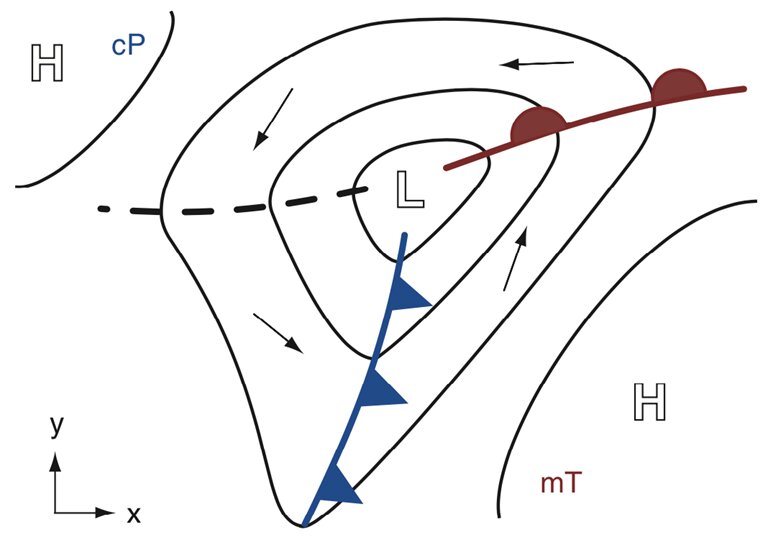
The following illustration shows a typical low-pressure weather system with both a cold front and a warm front. It includes several important symbols that pilots may encounter on U.S. surface weather charts.
Understanding the Diagram
-
The letter L — Low Pressure
The letter L near the center represents a low-pressure system. Notice that the cold front and warm front meet near this area. Low-pressure systems are commonly associated with rising air and changing weather conditions. -
The Blue Line — Cold Front
The blue line extends southward from the low-pressure area. Its blue triangles point toward the warmer air to the right of the line. This indicates that colder air is advancing toward and replacing the warmer air. The triangles show the front's direction of movement. -
The Red Line — Warm Front
The red line extends eastward from the low-pressure area. The red semicircles extend toward the cooler air ahead of the warm front. This indicates that the warm air mass is advancing into an area previously occupied by cooler air. -
cP and mT — Air Masses
The letters cP mean continental polar: a generally cold, relatively dry air mass. The letters mT mean maritime tropical: a generally warm, moist air mass. In this diagram, the contrast between these air masses helps explain the location of the fronts. -
The Curved Black Lines — Isobars
The solid curved lines represent isobars, which connect places having the same atmospheric pressure. Notice how they curve around the low-pressure center. When isobars are closer together, atmospheric pressure changes more rapidly over a given distance. This often indicates stronger winds. -
The Black Arrows — Wind Circulation
The small black arrows illustrate the general circulation of air around the low-pressure system. In the Northern Hemisphere, winds generally circulate counterclockwise around low pressure. Do not confuse these wind arrows with the blue triangles and red semicircles: the frontal symbols indicate the direction in which the fronts move. -
The Letters H — High Pressure
The letters H identify high-pressure areas. These are separate from the low-pressure system marked L. On a typical Northern Hemisphere surface weather chart, winds circulate clockwise around high-pressure systems. -
The Dashed Black Line — Pressure Trough
The dashed black line extending westward from the low-pressure center represents a trough, an elongated area of relatively low atmospheric pressure. A trough is not the same thing as a cold or warm front.
How should a pilot read this chart? First, locate the low-pressure center. Next, identify the cold and warm fronts. Then examine the direction of the frontal symbols and the position of the air masses. This gives you a general picture of the weather system and how it may affect different regions.
What a Frontal Line Does Not Show
A weather front on a surface chart marks the position of the frontal boundary at the surface. It does not show the complete area affected by the front.
Clouds, precipitation, and poor visibility may extend far beyond the line. For example, precipitation associated with a warm front can develop well ahead of its surface position.
Important for pilots: A frontal symbol identifies a weather system, but it does not tell you the exact ceiling, visibility, turbulence, or precipitation along your route. You need additional aviation weather information to evaluate those conditions.
You can view U.S. surface analyses and forecast weather products through the Aviation Weather Center .
Weather Fronts and Flight Planning
Understanding weather fronts is an important part of preparing for a safe flight. However, knowing the current position of a front is not enough.
A pilot must also consider where the front is expected to be during the flight and whether it could affect the departure airport, the planned route, or the destination.
Think ahead: The weather may be suitable when you depart, but a moving front could reach your destination before you arrive. Flight planning must consider both current conditions and forecasts.
Check the Front's Expected Position
Start by examining the current surface weather pattern and the forecast charts covering your planned flight time.
Compare the front's present location with its forecast location. Then consider your departure time, flight duration, and estimated arrival time.
For example, a front may be west of your destination when you take off. If it is moving toward the airport, the weather could change before you land.
The key question is not simply "Where is the front now?" but also "Where will it be when I get there?"
Check Weather Conditions Along the Entire Route
A frontal position provides an important overview, but pilots need more detailed weather information before making a decision.
METARs and TAFs
Check reported weather and airport forecasts for your departure, destination, and suitable airports along the route. Pay attention to ceilings, visibility, wind, gusts, and expected changes around your arrival time. Remember that a TAF describes conditions near an airport, not the entire flight route.
Radar and Satellite Images
Use radar to identify areas of precipitation and developing or existing thunderstorms. Satellite images help you see larger cloud systems. Remember that radar does not show every aviation hazard, including all turbulence.
Graphical Aviation Forecasts
Examine forecasts of ceiling, visibility, precipitation, wind, turbulence, and icing along the route. These products help identify potentially hazardous conditions between airports where observations may be limited.
Weather Advisories and PIREPs
Review applicable SIGMETs, G-AIRMETs, and other weather advisories. Pilot Reports (PIREPs) can provide useful information about conditions encountered by other aircraft, including turbulence and icing. A lack of PIREPs does not mean that conditions are safe.
These products are available through the Aviation Weather Center's Graphical Forecasts for Aviation and its related weather services.
Example: A Cold Front Along a U.S. Cross-Country Route
The following illustration shows a cold front affecting a region stretching from St. Louis toward Indianapolis, Columbus, and Pittsburgh.

- St. Louis: The city is shown on the colder-air side of the front, behind the advancing boundary.
- Indianapolis: The illustration places a large cumulonimbus cloud near the frontal boundary, with precipitation beneath it. This represents the type of significant weather that can develop near an active cold front.
- Columbus: The city is shown farther ahead of the cold front, within warmer air. Smaller clouds are illustrated in this example.
- Pittsburgh: The city is shown even farther ahead of the boundary. However, its distance from the front does not guarantee favorable flying conditions.
Imagine planning a flight across this region. If the route crosses the frontal boundary, the pilot must determine whether the weather near the front can be safely avoided.
The presence of cumulonimbus clouds is especially important. Thunderstorms can produce severe turbulence, strong wind changes, hail, and dangerous conditions outside the visible cloud.
Important: This illustration is only an example. Real cold fronts do not always produce the same cloud pattern, and thunderstorms do not occur at a fixed distance from a front. Never use a simplified diagram to estimate safe separation from an actual thunderstorm.
Plan for Weather Changes During the Flight
Once the pilot has reviewed the forecast weather, the next step is to consider how changing conditions could affect each part of the flight.
At Departure
Will visibility, ceiling, or surface winds change before takeoff? Could an approaching front make the departure airport unsuitable by the time the aircraft is ready to leave?
En Route
Is the planned route expected to cross a frontal boundary? Are there areas of low cloud, precipitation, or thunderstorms that could prevent the flight from continuing safely?
At the Destination
What conditions are forecast for the estimated arrival time? Consider the expected ceiling, visibility, wind direction, wind speed, and possible gusts during landing.
Alternate Airports
Identify suitable airports where the aircraft could land if the destination becomes unsuitable. Check their forecast weather and make sure enough fuel is available for a safe diversion.
Deciding Whether to Go, Delay, Reroute, or Cancel
Encountering a weather front does not automatically mean that a flight must be canceled. The decision depends on the actual and forecast conditions, the aircraft, and the pilot's experience and limitations.
GO — Conditions Are Suitable
The available weather information supports a safe flight, and conditions are expected to remain within both legal and personal operating limits, with a reasonable safety margin.
DELAY — Wait for Better Conditions
A front is expected to affect the route or destination near the planned flight time. Waiting may allow the pilot to depart after the hazardous weather has moved away, provided conditions are reassessed.
REROUTE — Choose a Safer Route
A different route may avoid the affected area. The new route must be checked for weather, terrain, airspace, suitable airports, and fuel requirements.
CANCEL — Do Not Accept the Risk
Conditions are unsafe, the forecast is too uncertain, or no suitable route or departure time is available. Canceling is the correct decision when a safe flight cannot be assured.
Keep Monitoring the Weather
Weather conditions can change after departure. Continue monitoring available weather information during the flight, especially when a frontal system is nearby.
Compare new reports with the original forecast. If conditions deteriorate, act early while safe options are still available.
Key lesson for pilots: The purpose of frontal analysis is not simply to identify a cold or warm front. It is to understand how the developing weather could affect your flight and make a safe decision before the conditions become a problem.